Capture the place
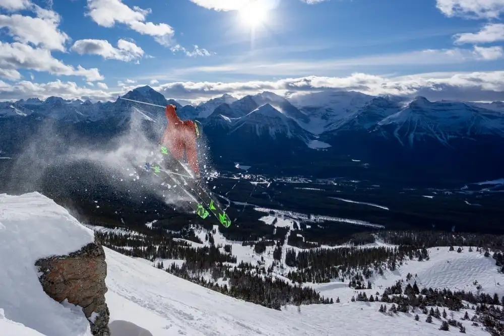
On-mountain action, wildlife, aurora, events, lifestyle, conditions, and visitor moments — shot with the terrain sense to be in the right place safely.
Action, wildlife, aurora, and guest experience — with 50+ images in active resort use and the web, map, and publishing systems that put them to work.
Action, wildlife, aurora, dining, and guest moments — selected from images the resort has already put to use on its website, signage, ads, and trail maps.
It all started with a day of taking photos with you... that was the beginning.
Former pro patrol, ten years on the mountain: the same field judgment runs from the camera to the publishing tools.
On-mountain action, wildlife, aurora, events, lifestyle, conditions, and visitor moments — shot with the terrain sense to be in the right place safely.
Local knowledge, resort operations, access, weather, terrain, guest flow, and visitor-facing context.
Fast public websites, maps, forecasts, search, publishing workflows, and offline resources that keep destination content working.
Each path leads to work that shipped — not promises.
A decade of resort experience across six departments, a patrol and safety background, and media the resort already trusts in public.
Resort-used action, wildlife, aurora, dining, and lifestyle work — each selected image shown next to the public surface where it shipped.
Fast static publishing, self-hosted maps and forecasts, search, deployment checks, and offline-ready workflows you can inspect live.
Live forecast cards, a self-hosted 3D terrain map, and publishing workflows — built and maintained by the same person who shoots the content.
Weather, road, precipitation, visibility, and confidence signals are shaped into one visitor-ready card.
Local elevation, water, roads, rivers, trails, lift lines, and labels render as a self-hosted map surface.
Structured content can become pages, search records, JSON data, PDF files, and offline guide material.
The public site stays static-first, cacheable, and checked before deploy so rich proof does not become slow proof.
Medium confidence forecast snapshot. Wind 0 km/h N. Visibility 14 km. Freezing level 2417 m and rising. AB-1 clear; BC check separately
wind 7 km/h; 0.7 mm rain; 0.3 cm snow; Low lightning
wind 5 km/h; 0.0 mm rain; 0.0 cm snow; Minimal lightning
wind 7 km/h; 0.0 mm rain; 0.0 cm snow; Minimal lightning
wind 7 km/h; 0.0 mm rain; 0.0 cm snow; Minimal lightning
API snapshot Jun 12, 09:36 a.m. MDT
The same build-time shaded relief that powers the static map below: real elevation, real lakes, no map library.
A visitor-facing conditions card built from weather observations, forecast output, road context, precipitation, visibility, freshness, and confidence.
A local terrain scene with water, roads, rivers, official trails, lift lines, and projected labels for destination-scale orientation.
A structured content workflow that can publish fast web pages and generate offline guide formats from the same source.
Each case study is structured around context, delivery, tools, proof, and what it demonstrates.
Photography and content support selected for websites, newsletters, advertising, signage, social, trail maps, dining pages, and visitor-facing resort content.
Photography and content production shaped by terrain, weather, wildlife, guest flow, and resort operations context.
A live weather and road-context surface that turns forecast data into a practical mountain decision card.
A self-hosted terrain map with elevation, water, roads, rivers, official trail geometry, lift lines, route context, and projected labels.
A publishing workflow where one structured source can produce public pages, downloadable PDFs, EPUB-style exports, and offline guide material.
A maintainable web architecture with typed content, optimized assets, static search, deploy checks, CDN delivery, and small live data surfaces only where needed.
Travis turns clear briefs into finished public work: plans, assets, pages, and tools. Written priorities and a defined decision owner get the deepest version of that work.
Available for photography, web/content, digital publishing, and mountain destination work where field judgment matters.